Showing posts with label Rainforest. Show all posts

Friday, July 29, 2011

Rainforest


view of tropical rainforest in Malaysia


Rainforests


Rainforest are forests characterized by high rainfall, with definitions setting minimum normal annual rainfall between 1750–2000 mm (68-78 inches). The monsoon trough, alternately known as the intertropical convergence zone, plays a significant role in creating Earth's tropical rainforests. There are two types of rainforest, tropical rainforest and temperate rainforest. Malaysia located near equator are blessed with tropical rainforest.

40 to 75% of all species on the world's habitats are indigenous to the rainforests. It has been estimated that many millions of species of plants, insects, and microorganisms are still undiscovered. Tropical rainforests have been called the "jewels of the Earth", and the "world's largest pharmacy", because over one quarter of natural medicines have been discovered there. Tropical rainforest are well known for its medicinal plants and herbs. Rainforest are also responsible for 28% of the world's oxygen turn over, often misunderstood as oxygen production, processing it through photosynthesis from carbon dioxide and storing it as carbon through biosequestration.


There is misconception  that to walk through rainforest is easy in believing that the undergrowth in a rainforest which is restricted in many areas by the lack of sunlight at ground level makes it possible to walk through, not like walking in the park though. Characther of forest floor or shrub layer not only determine by level of sunlight going through the canopy but also the type of soil. Granite soil would make it possible for a clear forest floor. Eventhough with a minimun amount of sunlight there would be vines plants tangle from forest floor struggle to rise to the highest canopy.  Forest floor composition of dense, tangled growth of vinesshrubs, and small trees called a jungle is determine by level of sunlight passing through the canopy . 
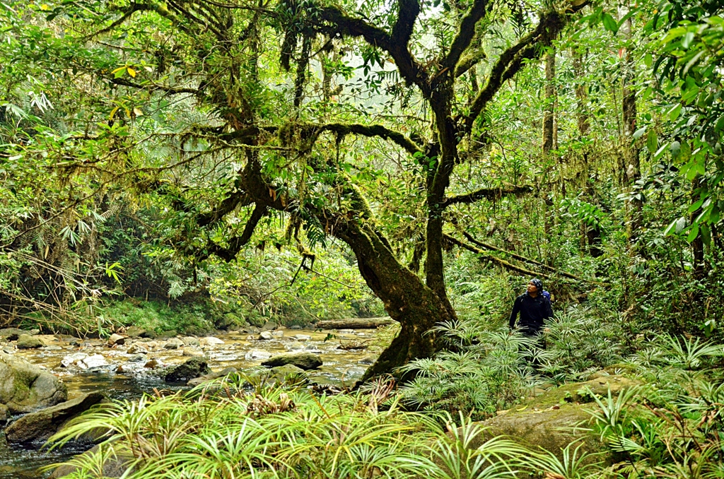
a hiker on beautiful scene of tropical rainforest trail
A hiker on Tropical Rainforest Trail beside a Small Stream. Click here for higher resolution photo


Tropical Rainforest
tropical Rainforest is a biome found within (roughly) 10 degrees north or south of the equator. They are common in Asia,AustraliaAfricaSouth AmericaCentral AmericaMexico and on many of the Pacific Islands. Within the World Wildlife Fund'sbiome classification, tropical rainforests are considered a type of tropical wet forest (or tropical moist broadleaf forest) and may also be referred to as lowland equatorial evergreen rainforest. Minimum normal annual rainfall between 1,750 millimetres (69 in) and 2,000 millimetres (79 in) occurs in this climate region. Mean monthly temperatures exceed 18 °C (64 °F) during all months of the year.
photo of tropical rainforest that show a small stream and layer of rainforest canopy
Photo of Tropical Rainforest


Temperate Rainforest
For temperate rain forests of North America, Alaback's definition is widely recognized:
  1. Annual precipitation over 1400 mm
  2. Mean annual temperature between 4 and 12 degrees Celsius. (39 and 54 degrees Fahrenheit)
However, required annual precipitation depends on factors such as distribution of rainfall over the year, temperatures over the year and fog presence, and definitions in other countries differ considerably. For example, Australian definitions are ecological-structural rather than climatic:

Plant in temperate rainforest are all predominantly coniferous, sometimes with an understory of broadleaved trees and shrubs. The conifer dominance is a consequence of two climatic factors: Although the region has high total precipitation, most occurs during the winter, and summers are relatively dry. During summer, moisture stress reduces the amount of photosynthesis possible especially for broadleaved trees. However, winters are very mild, and coniferous species are capable to carry on substantial amounts of their yearly photosynthesis during fall, winter and spring.


I would focus more on tropical rainforest as this is the kind of rainforest that involved and what I meant in all of my mountaineering endeavoring and bushing around. 

Layer of tropical rainforest


A tropical rainforest is typically divided into four main layers, each with different plants and animals adapted for life in that particular area: forest floor / shrub layers , understory, canopy, and  the emergent. Only the emergent layer is unique to tropical rainforests, while the others are also found in temperate rainforests. While plant in temperate rainforest are all predominantly coniferous, tropical rainforest are blessed with diverse plant species.
The emergent layer contains a small number of very large trees which grow above the canopy layer, reaching heights of 45-55 m, although on occasion a few species will grow up to 70 m or 80 m tall. Such species of emergent layer is Tualang tree.

The canopy is the primary layer of the forest and forms a roof over the two remaining layers. Most canopy trees have smooth, oval leaves that come to a point. It's a maze of leaves and branches. Many animals live in this area since food is abundant. 


Little sunshine reaches the understory layer, so the plants have to grow larger leaves to obtain sufficient sunlight. The plants in this area seldom grow to 12 feet. There is a large concentration of insects here.


The shrub layer and forest floor will be dimmer than other layer. Few plants grow in this area, as a result. Since hardly any sun reaches the forest floor things begin to decay quickly. 


All this layers can only be found on lowland Rainforest, as the contour change with increasing height the type canopy and layering also differ.


a trail in the middle of tropical rainforest


Related Articles
Malaysia Peat Swamp Forest
The Lost World of Maliau Basin
Unique of Malaysia Elephant

Tuesday, February 15, 2011

Maliau Basin

The Lost World of Maliau Basin Tawau Sabah


The Maliau Basin is a place set on a sprawling 588.4 square kilometers land in Tawau, at the South Central Part of Sabah. On south of Mount Kinabalu The area of Maliau Basin is bordered with crater like wall that fall hundred meters down that make it a separated area from the rest of rainforest which is why it's called Maliau "Basin". The isolated habitat has naturally protect its biome  from  human touch for so long until 1981 and nurtured the unique species of fauna and flora that exist there. Because of this condition Maliau Basin got its other name  "The Lost World of Malaiu Basin".


Maliau Basin contains an unusual assemblage of 12 forest types, comprising mainly of lower montane forest dominated by majestic Agathis trees, rare montane heath forest and lowland, and hill diperocarp forest. The highlight of the adventure is to trek the majestic 7 tiers Maliau Falls. 


Keen visitors must, however, obtain a permission to enter the Maliau Basin in advance from Yayasan Sabah. Also bear in mind that Maliau Basin is a remote, atavistic and isolated area with limited access, communications and safety facilities.


Activities & Tariffs

Nature explorers will simply love the Maliau Basin as it is an excellent site for jungle trekking and bird watching. At night, visitors may also take a night drive for wildlife spotting. Water babies can also take a dip in the beautiful waterfall.


Trips to the Maliau Basin are best done in large groups. A 5-day, 4-night stay at Maliau Basin costs RM2730 nett for 2 pax adults (Malaysian) and RM3610 nett (non-Malaysian). For a group of 8 to 12 people, the rate for adults is RM1450 nett (Malaysian) and RM2270 (non-Malaysian).


The rates in Ringgit Malaysia (RM) are inclusive of meals (breakfast, lunch and dinner), returned transfer (overland – Tawau to Agathis Camp), conservation and user fee (Campsites), rental of VHF radio, forest ranger cum radioman and guide.


Sime Darby offer help in SAFE project
Sime Darby has play its part towards environment and rainforest conservation by offering help in SAFE project and at the same time help lifting its Corporate Image as responsible company that know its responsibility towards environment other than enlarging its palm oil plantation at place of rainforest.


Deep in the heart of the Maliau Basin lies a lost world awaiting to be discovered by scientists and thrill-seekers.It is home to the largest ecological experiment ever established in Asia, and dubbed the Stability of Altered Forest Ecosystems (SAFE) project. SAFE is a 10-year project funded by the Sime Darby Foundation in collaboration with the Royal Society- Southeast Asia Rainforest Research Programme (SEARPP) and Sabah Foundation, which manages the Maliau Basin.


The SAFE project basically takes an in-depth look at how biodiversity is affected as forests undergo changes (from a primary forest to an oil palm plantation) which cause disruptions to ecosystem processes and services such as carbon sequestration, decomposition and pollination. And it is a huge task, considering that the Maliau Basin is as big as Singapore -- at 58,840ha. This is also the reason why it will take scientists at least 10 years before they can come up with the findings.


Sime Darby Foundation, which kicked off SAFE in January last year, is taking a big leap of faith in the project as the results may prove or dispel criticisms from environmental proponents that plantations are the destroyers of biodiversity.


Whatever the results, Sime Darby Foundation chairman Tun Musa Hitam, at the launching of SAFE, said they would serve to improve Sime Darby's commitment to conservation and sustainable development as the company was prepared to make the necessary changes to its management policy if need be.


For this purpose, Maliau Basin has a Research Studies Centre providing facilities to nature researchers and nature education programme participants. There's an office building equipped with a library, mini-theatre, reception and souvenir shop. Housing is also available in the form of dorms and plush VIP houses. There is also a laboratory where certain researches are conducted.

However, most of the actual research work takes place in the field at several satellite camps established within the Maliau Basin. Right now, scientists are working hard at finding the answers. In the meantime, scientists are on a gradual exploration of the Maliau Basin, which is also said to hold many "secrets".


Yayasan Sabah Group conservation and environmental management division group manager Dr Waidi Sinun said: "Maliau Basin is touted as a 'lost world' because the first successful human expedition to the area was only made in 1981.


"To date, scientists have only uncovered 20 per cent of the area, discovering a diverse range of flora and fauna."

"For example, more than 1,800 plant species have been identified, including six species of pitcher plants and more than 80 species of orchids. The rare rafflesia tengku-adlinii has also been found in Maliau Basin, one of only two known localities in Sabah."

"But more outstanding are the waterfalls. The uniqueness of the Maliau Basin is in its geology and the shape of the basin which creates an enclosed ecosystem. We have discovered more than 40 waterfalls.

"Among the most spectacular is the seven-tiered Maliau Falls. There should be more due to the shape of the basin."

Dr Waidi said scientists also discovered two new species of small fish, palm tree and several types of insects.

"We still have more space to cover. We hope that as we venture deeper into the basin, maybe in the next 50 years, we will be able to find new species of larger animals," he said.

The Maliau Basin is located near Tawau. From Kota Kinabalu, the Maliau Basin is a five-hour journey on logging roads by four-wheel-drive vehicles.


The Takob Akob Waterfall At Maliau Basin


Getting There

Maliau Basin Conservation Area is reachable by road either via Tawau or Keningau. The journey is on four wheel drive and depends so much on the weather as most of the journey is on logging roads to reach the Maliau Basin Security Gate. 


Journey from both Tawau and Keningau to the Security Gate of Maliau Basin Conservation takes 5 hours; the distance from Tawau to Maliau Basin Conservation Security Gate is 190 kilometers.


Flying is another fabulous option should you have extra allocations for this luxury. There are several helipads available which can be used for emergency evacuations or by visitors who prefer to fly rather than walk.


Further Information:

For further info, do pre-arrange with 

Borneo Nature Tours Sdn Bhd (KPL/LN 3719)

Block D, Lot 10, Ground Floor,

Sadong Jaya Complex,
88100 Kota Kinabalu,
Sabah, Malaysia

http://www.nst.com.my/nst/articles/15mmb/Article#ixzz1E2eJi5fG


Friday, February 4, 2011

Peat Swamp Forest

Peat Swamp Forest is tropical waterlogged lowland forest, where waterlogged soils prevent dead leaves and wood from fully decomposing, which over time creates thick layer of acidic peat. Peat swamp forest is actually transition of forest that gradually change through elevation from mangrove forest in coastal area, change into peat swamp forest and finally lowland rainforest. It is not actually have to be in that transition but easier to understand of Malaysia Rainforest hierarchy in such way.  Bukit Bauk Forest in Dungun Terengganu is good example of Hill Rainforest formed straightaway from pristine beach of South China Sea that choose to differ from this hierarchy. Peat Swamp Forest in tropical region is different from peat area of Europe or colder region which normally in  grassy form of wetland. Peat swamp forest in South East Asia region such as Kalimantan, Sarawak, Sumatra, Mekong and Raja Musa Forest Reserve in Selangor have more diverse vegetation with high canopy tree, and hosting some of rare and endangered species such as Meranti Bunga tree as well as wildlife. Orang Utan is a good example of wildlife that live in peat swamp forest habitat, this endangered species are all gone in Peninsular Malaysia and only left and survive in Borneo and Sumatra. In Peninsular Malaysia peat swamp forest can be found at MerangTerengganu, Sungai Karang and Raja Muda Musa Forest Reserve in Selangor, and Rompin in Pahang.

Wetland Putrajaya


Peat Swamp Forest Logged & Destroyed
Peat Swamp Forest is crucial in global climate control. The prime ecological function of peat swamp forest is its role as natural carbon sink, and its ability to absorb and store water to act as natural reservoir. What Kuala Lumpur Smart Tunnel is built for that cost Billion of RM to channel rainwater to special reservoir, this peat swamp forest could serve the same function naturally and that would value much more than that. It's reported that some of this peat swamp forest has more than 3 meter deep. The drainage of this peat swamp forest is afraid would cause ecological disaster to us, not only we will lost of natural flood mitigation system but the drainage itself will degrade the quality and natural function of peat swamp itself as carbon sink. Uncontrolled drainage would cause peat swamp forest to lose its moisture and become drier. This will effect forest regeneration. Botanist that study South Kuala Langat Peat Swamp Forest in Selangor has observed a lack of Meranti Bunga Tree seedling even in deep virgin Peat Swamp Forest. This could mean that the species is not reproducing perhaps due to deterioration of the peat soil.

Peat swamp forest act as carbon sink by accumulates and stores some carbon-containing chemical compound for an indefinite period in its reservoir. The process by which carbon sinks remove carbon dioxide from the atmosphere is known as carbon sequestration or biogeochemical cycle or nutrient cycle. This cycle is just like water cycle. Water, for example, is always recycled through the water cycle -  The water undergoes evaporation, condensation, and precipitation, falling back to Earth clean and fresh. Elements, chemical compounds, and other forms of matter are passed from one organism to another and from one part of the biosphere to another through the biogeochemical cycles. The same cycle also happen to carbon CO2. . Peat Swamp Forest would store carbon in its reservoir in long period of time. This will eventually turn into peat and coal. When chemicals are held for only short periods of time, they are being held in exchange pools. Examples of exchange pools include plants and animals. Plants and animals utilize carbon to produce carbohydrates, fats, and proteins, which can then be used to build their internal structures or to obtain energy. Plants and animals temporarily use carbon in their systems and then release it back into the air or surrounding medium. Carbon is held for a relatively short time in plants and animals in comparison to coal and peat deposits. 

A peat fired power station in Finland
Same as coal, peat from peat swamp forest could be used as source of energy. Peat can be used as raw material in electric producing power plant. This explained why a fire at drained peat swamp forest is hard to extinguished. Dry peat layer deep into the soil could burn for a long time and cause a lot of smoke. If left untreated this peat swamp forest with its abundant of raw power source could burn for months and cause thick haze. Open fire of peat swamp forest in Kalimantan and Sumatra in 1997-1998 and 2002-2003 has cause major haze problem that blanket main South East Asia Cities of Kuala Lumpur, Singapore  and Jakarta for months. Open fire is an easy and cheap way to clear peat swamp forest for plantation and agriculture.

Russia, Finland and Ireland are main power producer from  peat fired power station. It is some kind of weird for western country to accuse developing country of neglecting environmental responsibility while they at the same time contribute so much of carbon release. Westerner environmentalist call for developing Tropical Countries to stop deforestation of peat swamp forest and rainforest while they at the same time harvested  their peatland, this is like crap preaching other to crawl straight while they at the same time go sideway.

It is acknowledge that reclamation of the peat swamp forest for development is unavoidable. Malaysia for example has build its Kuala Lumpur International Airport KLIA and Sepang International Circuit on peat swamp forest and effectively cut through Kuala Langat Forest Reserve into 2, that create North and South Forest Reserve. Bit and pieces of it has become   oil palm plantation. However its important now for us to preserve and protect what is left. New development and new agriculture area should use and optimized what we already have of those unused and idle land. New rule could be formulated for government to utilize idle land instead of deforestation. 

We are losing our Peat forest as vast area of peat swamp forest continue to be cleared, drained and razed. Only one fifth (470,303ha) of the country's peat land are still relatively undisturbed with a forest canopy cover of over   70%1 . Peat Swamp Forest ecology system is sensitive because of it dependence on intricate balance  between hydrology, vegetation and soil. Most of this Peatlands lost is due to creation of new oil palm plantations. Hope that recent proposal by Selangor State Government to convert Kuala Langat South Forest Reserve into oil palm plantation would just be a proposal. Better still Selangor Government should think of way to promote Peat Swamp Forest as tourist destination. What we see in Putrajaya Wetland for example is a very good way to utilize it other than to turn it into another oil palm plantation. We have rainforest of Taman Negara Pahang that has been a proven tourist destination, so why not another Taman Negara for Peat Swamp Forest? not only it will be another attraction but also would reward us back environmentally. If the benefit of Peat Swamp Forest provide such as preventing saline water intrusion, flood mitigation,maintaining minimun flow in rivers, and carbon recycle can be value monetarily, then factored into decision making with regard to management of peatlands, the call would be for us to protect our remaining Peat Swamp Forest and the degraded one should be rehabilitated for sustainable use.


_____________

1. A Quick Scan of Peatland in Malaysia, by Wetland International, 2010 


Related Reading
@ Hiking Tips
@ Mount Kinabalu
@ Nike Free Run

Friday, June 18, 2010

Tualang Tree Koompassia Excelsa

Tualang Tree as what is called in Malaysia or scientifically known as Koompassia excelsa, is an emergent tropical rainforest tree species in the Fabaceae family. It is found in Indonesia, Malaysia, the Philippines, and Thailand. It is one of the tallest tropical tree species: the tallest measured specimen is 85. m or 88m tall.
Tualangs grow mostly in lowland rainforests where it towers over the canopy. Tualang has huge buttress roots to support it weight like most tall rainforest trees while not all huge rainforest tree share the same charactheristic like Merbau tree which has it trunk straightly rooted to the forest floor.


Tualangs only branch over the canopy (around 30 m) and have slippery trunks, which makes them attractive to the giant honey bees Apis dorsata that hang their huge combs from the branches. Even the bees cannot protect the trees from loggers, as nowadays tualang tree can only be found deep in the lowland rainforest. This special honey bee, deep lowland rainforest and Tualang tree are interrelated and inter connected, as giant honey bee (apis dorsata) habitat is only in deep rainforest this what make honey from Tualang tree nest is so special as what known as Madu Tualang in Malaysia, without vast rainforest to feed around there would meant extinction to this special honey bee, no honey bee nest on Tualang Tree and vice versa, no honey bee and no forest around it the big Tualang tree is more likely the first to go. The big tree absolutely worth more than the honey for loggers. What make this tree so special is bee hunter would make expedition into deep rainforest looking for Tualang tree to harvest honey. The trail leading to location of the Tualang tree would be marked and they would return annually to harvest honey. Tualang tree honey harvest technique and ritual is unique and well documented in books and documentary.


References
1. "Borneo". Eastern Native Tree Society. http://www.nativetreesociety.org/worldtrees/sea_ei/borneo_ii.htm. Retrieved 2008-06-12.
2.  Hou, D. Leguminosae (Subfamily Caesalpinioideae). In Tree Flora of Sabah and Sarawak, Volume 3, 2006. Soepadmo, E., Saw, L.G. eds. Government of Malaysia, Kuala Lumpur, Malaysia. ISBN 983-2181-06-2
3. Picture taken from http://digdeep1962.blogspot.com/2008/07/2nd-july-2008-bintang-hijau-forest_03.html and utusan.com.my

Temperate Rainforest

Temperate Rainforest
For temperate rain forests of North America, Alaback's definition is widely recognized:
  1. Annual precipitation over 1400 mm
  2. Mean annual temperature between 4 and 12 degrees Celsius. (39 and 54 degrees Fahrenheit)
However, required annual precipitation depends on factors such as distribution of rainfall over the year, temperatures over the year and fog presence, and definitions in other countries differ considerably. For example, Australian definitions are ecological-structural rather than climatic:

Plant in temperate rainforest are all predominantly coniferous, sometimes with an understory of broadleaved trees and shrubs. The conifer dominance is a consequence of two climatic factors: Although the region has high total precipitation, most occurs during the winter, and summers are relatively dry. During summer, moisture stress reduces the amount of photosynthesis possible especially for broadleaved trees. However, winters are very mild, and coniferous species are capable to carry on substantial amounts of their yearly photosynthesis during fall, winter and spring.

Tropical Rainforest

Tropical Rainforest
tropical rainforest is a biome found within (roughly) 10 degrees north or south of the equator. They are common in Asia,AustraliaAfricaSouth AmericaCentral AmericaMexico and on many of the Pacific Islands. Within the World Wildlife Fund'sbiome classification, tropical rainforests are considered a type of tropical wet forest (or tropical moist broadleaf forest) and may also be referred to as lowland equatorial evergreen rainforest. Minimum normal annual rainfall between 1,750 millimetres (69 in) and 2,000 millimetres (79 in) occurs in this climate region. Mean monthly temperatures exceed 18 °C (64 °F) during all months of the year.


Other than temperate zoning (latitude) that give distinct character of tropical rainforest, other climatic factors that determining tropical rainforest biome, especially plant and  organisms are humidity and elevation


Tropical rainforest found in Malaysia also known as tropical moist broadleaf forest (also share some character of tropical dry forest on dry season depends on regional climatic change) can be further calssified into:


 i) Flooded forests, including freshwater swamp forests and peat swamp forests.


ii) Lowland  tropical rainforests, are forests which receive high rainfall (more than 2000 mm, or 80 inches, annually) throughout the year.


iii) Montane rainforests, biome of tropical highland mountains range which are known as cloud forests , mossy forest or mountain forest, are found in cooler-climate mountainous areas. Titiwangsa Mountains Ranges from Mount Chamah and Ulu Sepat  till  Mountains in Perak such as Mount Irau, Cameron Highland  are well known for its mossy forest beauty.


      • Tropical coniferous forest - pine tree trail in Fraser Hill once have distinct character or tropical pine forest, however regional warming which correlated with deforestation and clearance of forest area for farming and plantation in nearby areas has reduce the size of coniferous forest area.


Layer of lowland tropical rainforest


A tropical rainforest is typically divided into four main layers, each with different plants and animals adapted for life in that particular area: forest floor / shrub layers , understory, canopy, and  the emergent. Only the emergent layer is unique to tropical rainforests, while the others are also found in temperate rainforests. While plant in temperate rainforest are all predominantly coniferous, tropical rainforest are blessed with diverse plant species.

The emergent layer contains a small number of very large trees which grow above the canopy layer, reaching heights of 45-55 m, although on occasion a few species will grow up to 70 m or 80 m tall. Such species of emergent layer is Tualang (koompassia excelsa) tree.

The canopy is the primary layer of the forest and forms a roof over the two remaining layers. Most canopy trees have smooth, oval leaves that come to a point. It's a maze of leaves and branches. Many animals live in this area since food is abundant. 

Little sunshine reaches the understory layer, so the plants have to grow larger leaves to obtain sufficient sunlight. The plants in this area seldom grow to 12 feet. There is a large concentration of insects here.

The shrub layer and forest floor will be dimmer than other layer. Few plants grow in this area, as a result. Since hardly any sun reaches the forest floor things begin to decay quickly. 

All this layers can only be found on lowland rainforest, as the contour change with increasing height the type canopy and layering also differ transform into montane rainforest.


Translate

TEKNIK PEMBAJAAN POKOK DURUAN

 Teknik membaja durian.   Jika baru tanam  1. lubang 2x2x2  baja cirp 100 gm  baja mgl 100 gm kokai 2-4 biji  baja organik kompos 2 kg   2. ...