Showing posts with label TRAILS. Show all posts

Tuesday, February 21, 2012

Bukit Keluang

Bukit Keluang in Besut, Terengganu

Bukit Keluang is an attractive place in Besut Terengganu with uniques beaches that is flanked with several hills; that is why it is called Bukit(hill) Keluang. For those who first heard its name might at first thought imagines Bukit Keluang as a green forested area in Forest Reserve with nice stream or on foot of a mountain. But that only half true..  because Bukit Keluang is actually facing the South China Sea with beautiful beaches and rock outcrop. This combination of beaches and rocky hill are what make this place so unique. While the beach is beautiful and good place for picnic and swimming, it is the hill that make this place so special. Climbing the Bukit Keluang hill will offer you a breathtaking view. Walking along the ridge with superb view and breezy wind is so peaceful. Climb of the Bukit Keluang would take around 30-60 minutes to the highest point. If you have more time to kill then proceed to hike the full trail.. 

seen is believing


the cliff is so high, even at my lens full zoom of 105mm, the anglers below still look so tiny
MAP.. HOW TO GO TO BUKIT KELUANG
Click here to view Bukit Keluang in a larger map


Thursday, June 2, 2011

Saga Hill

Saga Hill Map, Cheras Kuala Lumpur


Located just on the fringe of Kuala Lumpur city centre, Saga Hill is the ideal place for riadah and sport activity, for mountaineer to practice before big expedition, white man and Eskimos to experience natural tropical rainforest, urban dweller to change skin for a jungle warrior,  a place to meet up for get together  activity with long not to see hiking gang, or simply want to meet with the uncles and aunty that conquer this Saga Hill every weeks, that is why this Saga Hill got its other name = Bukit Apek / Apek Hill. If these uncles and aunties climb this hill 1-2 rounds in a morning then more will for all of you fitness buff.

May be not as popular as Broga Hill that offer unique view of  lalang and unobstructed view. This Saga Hill does offer unique attraction such as waterfall, shaded trek, and real trekking experience minus crowd like Bukit Broga / Broga Hill. Going to Saga Hill you don’t have to wake up early in the morning to avoid hot scorching sun as the trek is fully covered by rainforest tree canopy, I even suggest for you not to be too early to climb Saga Hill as the trek could be not so well lighted due to well covered canopy and morning mist. Furthermore, it is located nearer to Kuala Lumpur City Centre than Broga Hill. Don’t believe all I said, follow this Saga Hill map and enjoy Saga Hill trail by yourself! Pack your breakfast and have it at the camp on one of its peaks, then proceed to explore its entire trails. From foot of the Saga Hill to its peak took nearly 45minutes to complete for average climber. Saga Hill have several routes that was named as route A, B, C & D which is need around 1 half day to complete or take it easy to come another day for a different route. Enjoy Saga Hill!!


View Bukit Saga in a larger map


The main prize of Saga Hill trail - A small but beautiful waterfall that flow on big rock flat face with beautiful landscape and small area for  picnic. Very ideal place for picnic and photoshoot if you have the place all for you..  but most of the time this "small" place is crowded with hikers


Related Article
Gunung Tebu, Terengganu

Wednesday, March 16, 2011

Bukit Tabur East

Bukit Tabur East or Tabur Hill East Taman Melawati Kuala Lumpur

Bukit Tabur East is a lesser known trail of Bukit Tabur Quartz Ridge compare to its more popular Bukit Tabur West trail. This is mostly due that Bukit Tabur East is more difficult and more dangerous to climb. In contrast with  Bukit Tabur West that you will have gradual climb where the trail is not so steep, this trail have more steep incline straightaway  meters into the trail. Bukit Tabur West have better view of Kuala Lumpur City Centre while Bukit Tabur East that sit further far at North Eastern side have good view of lush rainforest reserve and Klang Gate Reservoir. Bukit Tabur West offer scenic view of sunrise with Bukit Tabur East as prop at the foreground. Bukit Tabur East starting trail is facing north east with the ridge blocking morning sun ray would make the trail quite dark at the early morning. There will be a few rope to assist climb to reach at first View Point. Highest peak (fourth peak) of Bukit Tabur East  is at 900 feet just  around ten feet higher than Bukit Tabur West at 850 feet. Other than the first shaded rest point which offer good view of Klang Gate Reservoir and Forest Reserve, the rest of the trail on the ridge is quite exposed to sun light other than some parts that descend into some small forest. To reach the fourth peak of Bukit Tabur East hiker have to climb a nearly 75% steep wall. Small rope is fitted there to assist climber but I would prefer to climb without it for a more stabile and balance climb. Before the fourth peak there are small alternative trail for climber to descend that going through some small forest and exit beside some bungalow houses. Extra precaution should taken on passing through second peak as you have to climb on jagged boulder while going beside it is quite dangerous which you have to walk on narrow ledge with very high cliff  below, hike here during night time and bad visibility is dangerous. Descending toward forest trail from first peak should be done in orderly  and sensible movement as any mistake at some cliff would bring your fall more than 20 meters below and at some parts it could be higher. There are a lot of fall accident here wether reported or unreported incidents, so taking extra precaution is advisable.


View Bukit Tabur East and West Kuala Lumpur in a larger map


Park you car here to climb Bukit Tabur East, there are ample space to park 10-20 cars


Starting Point of Bukit Tabur East at the end of small road along big water pipe

First Part of the Bukit Tabur East trail have a denser forest compare to Bukit Tabur West  with denser undergrowth and bigger tree

"Good Virgin" Tree
steep trail up to the first peak

Raw quartz that you will find on the middle of the Bukit Tabur East Trail - The Longest Quartz Ridge in The World
First View offer direction of Klang Gate Dam Reservoir and Bukit Tabur West Ridge
view of Bukit Tabor West, On close up you could see hikers on the ridge

Zoom over hikers on Bukit Tabur West
other formation of quartz on way up

At the first Peak of Bukit Tabur East. Suitable place for rest before proceed to other higher peaks.  Surrounding tree offer cool shade for a good rest point and having hot tea and view from here is magnificent. A good spot for group photo too :) .. one group of hiker that we met
View From Resting Point

Wall Climbing At the Highest Peak of Tabur Hill East

At the peak of Bukit Tabur East with Bukit Tabur West on the background
looking East from the highest peak of Bukit Tabur East at more jagged peak of the quartz ridge, 

Dangerous cliff on the way down just before the first rope, if you trip your feet here, you will fall 20m down below. I know one guy who free fall from this cliff, luckily he fell on his backpack and survived with not so serious injury
Related Articles

Saturday, February 19, 2011

Bukit Tabur


Map / Peta to Bukit Tabur West Melawati  Kuala Lumpur


This map is to show direction from Highway MRR2 to starting point of Bukit Tabur trail. From MRR2 exit at junction of jalan Genting Klang and Jalan Kolam Air. Take direction toward Jalan Kolam Air. You have choice whether to  go straight until the end of Jalan Kolam Air or take right to Jalan Taman Melawati until roundabout of Taman Bukit Mas. Take direction of 9 o clock  until reach back Jalan Kolam Air and take right. From here you will notice that the road will be narrower into single lane through housing area and hilly jungle. The road is not so good and you will passing by some small waterfall on your left. The road will end at entry point of Klang Gate Dam. Starting point of Bukit Tabur trail start 20 meter before the Dam's main gate marked by small cement stair. View this map to Bukit Tabur Kuala Lumpur through Google Maps. Choose satelie view for more clear direction.... Wish you all Have a Nice Hiking Trip at Bukit Tabur.


View Bukit Tabor Kuala Lumpur in a larger map


me at Bukit Tabur


Related Articles

Broga Hill

It's quite amazing that A barren Broga Hill with all its original tree burnt, not exactly known cause of the fire whether by accident or simply deforested for agriculture, could transform into a quite unique landscape. What normally happen to rainforest after clearing would never restore itself to its former stage unless it is rehabilitated or just wait for thousand years. It could turn into bush of "resam" (large fern) or field of "lalang" cogon grass (Imperata cylindrica)   like this Broga Hill /Bukit Broga that is why it is also called Bukit lalang . What make this landscape a becoming public attraction is Broga Hill offer view! human love view of landscape, even elephant do. What normally hill with lowland rainforest is full with high canopy tree and thick layer of plants would block view and with temperature / humidity rising with sunrise, I beg not everyone love to be there :) .. Cleared rainforest hill with nice view come with a price, the sun will shine bright directly to you, even pass 9.00am it will becoming harder to handle unless you are a tough nut with hard shell.  Bring an umbrella will not make you like aunty or uncle going to market, moreover others will salute your wisedom he he... Hiking up broga hill is fun. Fun to see many kind of people there, from though and fit mountain climber to excited sissy squid, from baby to old people. All seem to enjoy Broga Hill so will you.. so this map of how to go to Broga Hill aka Bukit Broga, hope will be a beneficial guide to you to go there

From Kuala Lumpur you can take either PLUS highway, exit at Kajang Toll or SILK highway from Cheras to Semenyih. From either route go to Bandar Semenyih. From jalan Semenyih heading to Seremban (old road), look for Raja Muda Mosque on the right, just after Police Station on your left, go straight, 200meter after Petronas Station turn left to Broga at juncntion toward Broga Town. Several km forward you will able to see Broga Hill from afar on your left. Around 2km after University of Nottigham campus look for small patch of palm oil  plantation  on your left and rabbit farm on your right... park your car by roadside or in the plantation for a charge RM2 per entry :) 


View Bukit Broga / Hill Semenyih in a larger map


From Raja Muda Mosque on the right, just after Police Station on your left, go straight, 200meter after Petronas Station then turn left to Broga at juncntion towards Broga Town
If you like hiking on Broga Hill trail you might also like to hike Saga Hill Trail. In contrast from Broga Hill landscape and vegetation of cogon grass (Imperata cylindrica), Saga Hill still have its protected natural lowland and hill dipterocarp rainforest. The rainforest provide complete canopy over the trail. While it is hot on Broga Hill after 9.00am, there at Saga Hill is still envelope with mist and cold breeze.The hill is located at fringe of Kuala Lumpur City Centre is easily accessible through Taman Saga or Taman Ceupacs. One of attraction at Saga Hill is its waterfall. While it is just a small waterfall but is worth it after hours of hiking. Read more about Saga Hill here.


Related Article

Thursday, February 3, 2011

Gunung Kinabalu


CLIMB GUNUNG KINABALU SABAH BORNEO MALAYSIA


Gunung Kinabalu is the highest mountain in Malaysia with height of 4,095 metres (13,455 ft). Place of Gunung Kinabalu among highest mountains in South East Asia is conflicted over different viewsIt is located in Kinabalu National Park (a World Heritage Site) in the east Malaysian state of Sabah- coordinate 6° 5′ 0″ N116° 33′ 0″ E. Gunung Kinabalu has several peaks and the highest peak is Low's Peak. Gunung Kinabalu and its surroundings are among the most important biological sites in the world, with over 600 species of ferns, 326 species of birds, and 100 mammalian species identified. Among them are the gigantic Rafflesia plants. Gunung Kinabalu has been accorded UNESCO World Heritage status.


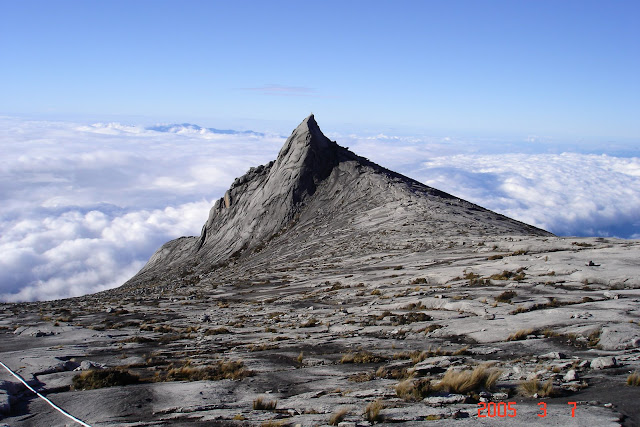
South peak - one of Peaks on Gunung Kinabalu, The highest peak is Low's Peak
South Peak of Gunung Kinabalu

At more than 4000 meters height. Gunung Kinabalu in Sabah is not only the highest point in Malaysia, it is also the highest point in South East Asia. This is one of must climb mountain in Malaysia for its beauty and challange. I climbed this Gunung Kinabalu in Mac 2005 and truly astounded by its unique beauty. The climb would take two days preferably. It include spend one night at Laban Rata hut before summiting in the early hours of the morning in time for sunrise on Borneo’s highest point. The climb is not particularly technical but it is real test for fitness and endurance. However it does offer opportunity for wall climbing enthusiast to test skill on various kind of rock face on the granite plateau. Check this couple wall climbing experience around Gurkha Hut - http://joannestamplis.wordpress.com/2008/11/09/borneo-part-2-mt-kinabalu/ . Some guide and tips about hiking hope would help you to climb Gunung Kinabalu succesfully.

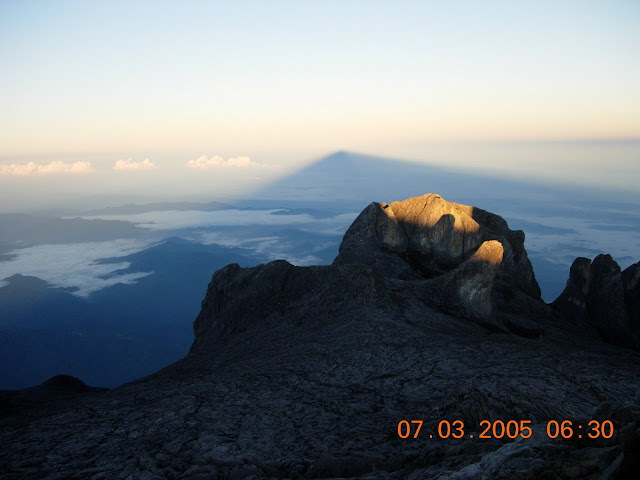
shadow of Gunung Kinabalu at sunrise
Shadow of Low's Peak fall on Horizon as sun rise over

Gunung Kinabalu gives you opportunity to experience different kind of climate as your climb increase along the trail. From thick rainforest with high tree gradually changes to pine tree and shorter bonsai, small orchid and finally barren granite at the final part of the mountain on the summit plateau. The temperature gradually drops at higher altitude and with sun move down for the night. For local climber this is only mountain in Malaysia that could give you altitude sickness. Steep ascend from Timpohon base camp and high gain of altitude in short period could give problem for some as your body don’t have enough time to acclimatize. From my experience dizziness that someone could feel as reaching Laban Rata or Gunting Lagadan could be relieved by taking hot shower, not need for Panadol or aspirin. The trek is clear and properly maintained. Proper stairs even built on certain part of the trail. You could climb Gunung Kinabalu in stylish way in your new designer sport pant and flashy sport shoes as it’s won’t likely that your pant got shred by thorny rattan, got stuck in mud or crawling for way unless you drop yourself on the slippery trek. Bear in mind that the trail is constant ascend from the start, all up no down and not much flat part. There are various routes to Climb  Gunung Kinabalu such as Mersilau and Timpohon trail which is differ in term of difficulty level and day taken and require some technical climbing. For normal climber it is better to stick on the commercialize route. There are also various mountain hut on the plateau such as Gurkha hut that reaching these huts would require different pass than the normal one.


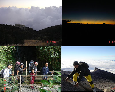
at beautiful Gunung Kinabalu Cliff on the way down to Laban Rata


Sunrise at Gunung Kinabalu highest peak = Lows Peak


Avoid raining season from September to Disember. The best time to climb  Gunung Kinabalu would be in month of March and April when the wether is normally dry and less rainfall. The forecast based on amount of rainfall permonth but mountain rain is unpredictable. You may start with shining morning sun, trekking in the rain around afternoon, sorround by fog at some part and arrive in the evening with clear sky and nice sunset.


Trip to  Gunung Kinabalu may not be complicated as trip to Mount Everest in logistic or technicality. But well prepared trip is essential to ensure comfortable and enjoyable trip so it worth your money and effort. More importantly your summit attempt is successful. This writing may not provide detail information but may give you some hint sight on what to prepare for the climb.
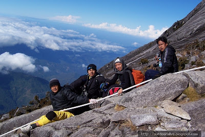
Just below Gunung Kinabalu Lows Peak

 First Day Climb Gunung Kinabalu

Normally climber will spend the first night at Hostel in Kinabalu Park at the foot of the Mountain and start climb in the morning. Nowadays Management Company of the Park has provided complete package inclusive of Food and Accommodation.  Some of the hostels are equipped with kitchen area so climbers could prepare their own meal for the night, breakfast and pack lunch. Better check with the new management for latest policy. You could arrange with hostel official to leave some of your things at the park and only bring essential and adequate stuff for the climb. Transportation is provided to ferry climbers from hostel to starting point of their choice either through Timpohon or Mersilau Gate. If the package is expensive for you, there are several hostels just outside Gunung Kinabalu Park's entrance that offer decent accomodation.

1. Wear light for first day Climb. How many clothes that you want to bring up depend on how many you want to change. Basically it can be divided into two type of clothing

1.1. Trekking Clothes – How many pieces you want to pack depend on how many you want to change for ascend, summit and descend trip. If you want different clothes for each one you will end up with more than 6 pieces of wet clothes at the end of Gunung Kinabalu trip. My suggestion is to prepare for two set of inner wear made from quick dry material. One or two set of quick dry T-shirt (one specifically for summit attempt) and two light pants or 1 pant and 1 short. If lighter pack more important to you, use the same outer clothes with different tight / inner wear :). You may prefer a complete dry and new clothes for each trekking but believe me it will get wet with your sweat within minutes. Gunung Kinabalu is located within tropical rainforest whis is high in humidity. Your body tendency to sweat is increase with humidity.

1.2. Sleeping and Non Trekking attire. After 6 hours of trekking for the day all you need is warm bath and dry cloth to enjoy evening fresh air around Laban Rata various huts. Your evening/ sleeping attire could be your second trekking attire. Don’t forget to try Sabah tea at Laban Rata lodge.


Laban Rata Hut at Gunung Kinabalu
At Laban Rata, Before Descend to Timpohon Gate


2. Pack enough drinking water, snack and food. The climbing could be draining your energy level to zero, so ensure a constant level of energy to keep you going or you will moving slow or not able to move at all, then you will be a liability to your group and your guide. Or you could choose to be a famous person next morning by calling air rescue :p

3. Water proofing. Pack your things in plastic bags in case it rains. Bear in mind that you will ascend through at layers of clouds height. Even not a heavy rain, you may encounter a light drizzle that could soak you wet in the middle of trail. Even though there are various rest huts available through the Gunung Kinabalu trail as shelter, the distance between these huts could be nearly in an hour. You also don’t have luxury of time to wait for a complete stop of rain as you might arrive late at Laban Rata. Pack separately between clothes, electronic gadget and group rations. There various type of waterproofing in the market. Check it out here http://mycorezone.com/

4. Lip gloss- sun tan lotion.. not essential but you may need it if skin perfection is your main concern.

5. Cap – Some kind of sun shade is essential especially during descending from Gunung Kinabalu's peak to Kinabalu park. The morning rising sun will be direct and not much shade of high tree for you.

6. If you have so many things to bring along but too heavy to carry by yourself, just hire a potter.. problem solved.

On Gunung Kinabalu summit attempt

Summit attempt will usually start 2-3 hours after midnight to take advantage of clear sky and less fog. At 4,095 meter height, temperature at Gunung Kinabalu can be quite cold, but as it is situated in tropical region the temperature would not be as cold as Mountain in Colder region even though there was report of snow on summit plateau before. Cold may be your main concern as you ready for summit climb at 3 a.m but bear in mind that you will feel hotter and sweat out as climb become harder so breathable choice of clothing is very important, do not wearing too light either as cold wind would be unbearable as you stop for a rest. So you have to prepare accordingly, no need for complete insulation but do not be too simple either. My suggestion is here…

1-Glove – for two purpose; one to warm you from windy cold night on Gunung Kinabalu granite Plateau, two to protect your hand while using rope. Chose for waterproof material. Its going to be cold, windy and the rope are wet. Wet glove are worst than bare hand on chilly night, but your hand will have some protection when hanging on the rope. I'm afraid you will even thinking of not using the rope. If your are on budget then buy latex glove (RM1?) as your base then put those wool construction worker style glove (RM5 buy this at hardware shop) on top of it as protection. Thus you have enough protection and dry hand! even though its not gonna be totally insulated from cold though.

2-Breathable outer jacket / windbreaker with hood, have water resistant or water proof material, this may not protect you from the rain but at least keep you dry from night fog. Preferably 2 layer jacket; outer layer to protect from mist and cold wind while inside layer will prevent your skin in contact with cold outer layer.

3-Light rain coat.. the disposable type would do.. but don’t dispose it on the Mountain please. It’s very cold up there, can’t imagine when it is raining ..so better be prepared.

4-Quick dry t’shirt – always opts for light and quick dry T-shirt. You will value it once you experience what it feel like when standing in blowing cold wind with sweaty wet T-shirt

5-Quick dry Tight

6-Light pant. (preferable with quick dry material)

7-Light shoes with rubber outsole track. Choose for grip flexible soft rubber rather than hard safety boot as wet granite surface on Gunung Kinabalu Plateau could be very slippery. No option for slip and fall on hard granite worst still fall and slide into gully. Read this guide to choose the right hiking shoes , I would personally recommend Adidas Adizero XT or Adidas Kanadia Trail. Both shoes have excellent grip, tough yet flexible outer sole.

8-Cap / snow cap. Heat first leave human body trough your head, so cover it up will made your feel warmer.

9-Headlamp – No No for torch light, you need both of your hand to hold on rope and cliff.

10-Small backpack – for water, raincoat, spare headlamp, spare battery, drinking water and small food ration/ energy bar.


THE HIGHEST MOUNTAIN IN SOUTH EAST ASIA?

Gunung Kinabalu is the highest mountain in Malaysia and the highest mountain in South East Asia (SEA).. Some may argue that there several mountains higher than  GunungKinabalu such as Mount Puncak Jaya (Carstenze Pyramid) in Irian Jaya or Mountains in Myanmar. Puncak Jaya located in Indonesia which is member of ASEAN but Irian Jaya Island is located on tectonic plate of Oceania which is not of South East Asia, thus disqualified the mountain as the highest mountain in SEA. If we want to consider mountains in Myanmar we will end up not knowing the final list because a lot of Mountain Peaks there still not yet discovered. At North of Myanmar laying the end of himalaya mountain range with various Mountain peaks higher than Puncak Jaya and Gunung Kinabalu but this mountain range in located on Asia Mainland not specifically as SEA. Then the highest Mountain in SEA is  Gunung Kinabalu :)


gunung kinabalu view from Manukan Island
View of Gunung Kinabalu from Manukan Island

More Information of Gunung Kinabalu

Visit Official Website of Sabah Tourism Agency for detail information on Gunung Kinabalu and other actractive places in Sabah Borneo
http://www.sabahtourism.com/sabah-malaysian-borneo/en/destination/124-kinabalu-park/


Translate

TEKNIK PEMBAJAAN POKOK DURUAN

 Teknik membaja durian.   Jika baru tanam  1. lubang 2x2x2  baja cirp 100 gm  baja mgl 100 gm kokai 2-4 biji  baja organik kompos 2 kg   2. ...